Showing posts with label curve. Show all posts

Wednesday, 3 February 2016

14. “The Lieutenant-Colonel Portlock experiment used oxy-hydrogen Drummond’s lights and heliostats to reflect the sun’s rays across stations set up across 108 miles of St. George’s Channel. If the Earth were actually a ball 25,000 miles in circumference, Portlock’s light should have remained hidden under a mile and a half of curvature.” 

The source is the same, the alleged “Doctor” Rowbotham of very dubious qualifications and medical understanding.  See Garwood, Christine (2010). Flat Earth: The History of an Infamous Idea Pan Macmillan.

And again, the numbers are wrong. 

It’s quite possible to see that mountain in Ireland from the Welsh Preselli Hills. The height needed is 1,437 feet, and the highest peak in Preseli is 1,759 feet. No problem.


http://the-uncredibles.tumblr.com/post/130629473404/200-pensb-14-lt-col-portlock


As Daimonie puts it,  “Another way of saying Dubay don't understand what the horizon is. See approximately all previous points” .


13 “In a 19th century French experiment by M. M. Biot and Arago a powerful lamp with good reflectors was placed on the summit of Desierto las Palmas in Spain and able to be seen all the way from Camprey on the Island of Iviza. Since the elevation of the two points were identical and the distance between covered nearly 100 miles, if Earth were a ball 25,000 miles in circumference, the light should have been more than 6600 feet, a mile and a quarter, below the line of sight!”

Hurray – a new point at last. Unfortunately… it makes little sense, because the numbers quoted are wrong.

First, a reference for this to a real science publication would help to check on the decidedly dodgy figures claimed.

Mr Dubay does not provide the elevation of the two points. It seems the height of the summit of Desierto de las Palmas is: 729 meters, or 2390 feet at Bartolo peak.

There is nowhere on the island of Ibiza that is particularly close to being 2390 feet high as the highest point on the island, Sa Talaiassa, is 475 meters, or 1558 feet, high. Oops, Mr Dubay has a real problem with facts.

The apparent source for this claim, Zetetic Astronomy Samuel Birley Rowbotham (1816–1884) seems to have messed up the mathematics more than somewhat.

See the following for more details and diagrams:


http://the-uncredibles.tumblr.com/post/130511368809/200-pensb-13-biot-and-arago-experiment


Stop Press! Dubay and his sources amazingly wrong again!


Since I posted the reply above, I've seen this, showing that almost everything in the claim is wrong. What a surprise...:

SPOILER ALERT: This post is very boring, and mostly pointless: not even flat earthers use this 'proof', and Dubay seems to have gone somewhat out of fashion, but I include it here because: a) I did the research already; b) others debunking his list on their blogs hadn't quite figured this one out; c) it's maybe good that it exists somewhere; and d) it's a great example of how Dubay has compiled, presented, and (not) researched his material.

So...

At number 13 in his list (video/self-published book/website) of "200 Proofs the Earth is not a Spinning Ball", Dubay says that:
As usual, this is a fairly direct quotation from one of the Victorian flat earth texts, this time Samuel Rowbotham's "Earth Not a Globe" (1872):

https://books.google.com.mx/books?id=VeBivA6QSEUC&pg=PT47&lpg=PT47&dq=rowbotham+biot+arago&source=bl&ots=2aR3V-9udm&sig=987ij9hMEVA5TGHe_h8H4U2I85o&hl=en&sa=X&ved=0ahUKEwis1Z3Z7bnOAhUG2WMKHbVZDjYQ6AEIKzAD#v=snippet&q="In the account of the trigonometrical operations"&f=false
POINT 1: While almost repeated word-for-word, there are a few important changes to note. First of all, Dubay has chosen to call the "trigonometrical operations" a "French experiment" - probably to make it look like a flat earth test rather than the measuring of the globe that it actually was - and, rather than Rowbotham's "nearly the same" elevation of the two points, he has claimed they were "identical." This is a pretty amusing assertion, given neither he nor Rowbotham knew where the points actually were.

POINT 2: Another fun one. When reading the text out, he says, "M. M. Biot", as though these were the guy's initials. "MM." actually means "messieurs" - ie, "Misters Biot and Arago." Biot's first name was Jean-Baptiste.

TITBIT 1: Biot and Arago were two French physicists, astronomers, and mathematicians - and certainly not flat earthers - who, in 1806, took on the work of measuring the meridian arc which passes through Paris in order to determine the exact length of a metre. It was a pretty Herculean and adventurous task, taking many years and involved scaling mountains, being arrested as spies, and subsequent escapes from the Spanish authorities. Quite the dedication to science!

POINT 3: The Desierto de las Palmas is a mountain range in the Spanish province of Castellón. The highest peak is called Bartolo, and it is from here that Biot and Arago made their measurements, as recorded on page 20 of "Memorial du Depot General de la Guerre, Volume 7". The elevations given are between 726.36 metres and 728.29 metres (2383 and 2389 feet).

This demonstrates that Rowbotham clearly had no idea of the elevation of the summit of Desierto de las Palmas, since it would be impossible for the two points to be "nearly the same" - the highest point on Ibiza is 1558 feet, and this wasn't the point Biot and Arago were using.

TITBIT 2: From "Report of Observations Geodesic, Astronomical, and Physics" by MM. Biot and Arago (1821):

https://books.google.com.mx/books?id=3iYyAQAAMAAJ&pg=PA79&lpg=PA79&dq=observations+geodesiques+desierto+de+las+palmas&source=bl&ots=JgkxN7VeTq&sig=2LZulESyPdx7gR085a0GWsfRhqc&hl=en&sa=X&ved=0ahUKEwjcppuFirrOAhVCKGMKHRN8BqsQ6AEIHTAA#v=onepage&q=observations geodesiques desierto de las palmas&f=false
POINT 4: While Biot and Arago called the point on Iviza (Ibiza) "Campvey", Dubay copies Rowbotham in calling it "Camprey": presumably because the original publication's "v" looks a little like an "r". Either way, I wasn't able to locate anywhere called Camprey or Campvey on Ibiza now - though, oddly, it shows up on some German sites as an Ibizan peak with an elevation of 396 metres. Handily, this matches the elevation reported by Biot and Arago, on page 9 of the aforementioned "Memorial du Depot" (and elsewhere), making it a good 1090 feet below the summit of Bartolo - ie, not exactly "identical."

Using the metabunk curve calculator, and a distance of 100 miles (Rowbotham got that much right) this shows us that at least 224 feet of Campvey should have been visible from Bartolo.

Claim #13, therefore, is debunked.


FURTHER QUESTIONS

1. Where is Campvey exactly? A topo map of Ibiza locating a peak of 396 metres/1299 feet about 100 miles from Bartolo should do it.

Or, in the aforementioned primary sources, latitude and longitude are given for Bartolo as 44.54/+2.56 and Campvey as 43.4/+1.09, but I can't work out what these refer to. Did they have a different system back then? After all, these measurements were taken a good 70 years before the prime meridian was established

2. In the 1870 edition (Volume 7, 4th Series) of "Chambers's Journal of Popular Literature, Science and Arts" the story of Biot and Arago is told, and it's possible this is where Rowbotham took his information, given that he uses the journal in some of his other 'proofs'. The Chambers account seems fairly scientific and straightforward, though, but I can't read all of it, as the digitised google books version isn't available in full-view.

3. Will I do research like this on any more of Dubay's 'proofs'? Hell no! Thorough investigation of this and "#4: Rivers Flow Uphill" (link to metabunk thread) - plus glances at some of the others - has told me pretty much everything I need to know. Hopefully the same can be said for any other sane-thinking person too.

Sorry for the tedium! 


11 “A  surveyor and engineer of thirty years published in the Birmingham Weekly Mercury stated, “I am thoroughly acquainted with the theory and practice of civil engineering. However bigoted some of our professors may be in the theory of surveying according to the prescribed rules, yet it is well known amongst us that such theoretical measurements are INCAPABLE OF ANY PRACTICAL ILLUSTRATION. All our locomotives are designed to run on what may be regarded as TRUE LEVELS or FLATS. There are, of course, partial inclines or gradients here and there, but they are always accurately defined and must be carefully traversed. But anything approaching to eight inches in the mile, increasing as the square of the distance, COULD NOT BE WORKED BY ANY ENGINE THAT WAS EVER YET CONSTRUCTED. Taking one station with another all over England and Scotland, it may be stated that all the platforms are ON THE SAME RELATIVE LEVEL. The distance between Eastern and Western coasts of England may be set down as 300 miles. If the prescribed curvature was indeed as represented, the central stations at Rugby or Warwick ought to be close upon three miles higher than a chord drawn from the two extremities. If such was the case there is not a driver or stoker within the Kingdom that would be found to take charge of the train. We can only laugh at those of your readers who seriously give us credit for such venturesome exploits, as running trains round spherical curves. Horizontal curves on levels are dangerous enough, vertical curves would be a thousand times worse, and with our rolling stock constructed as at present physically impossible.””

This  is just a repetition of  the false claim in point 7, using a weirdly ill-informed historical quote from an evidently incompetent engineer. 

Incompetent, that is, if he thinks a locomotive couldn’t manage an incline of 8 inches in a mile.  He also makes a childish howler by assuming that he can multiply  up the difference between the east and west coats of Britain and add the product to one end. Why does that make the slightest sense?

But in any case, it’s the same foolish inability to understand that moving along,  around the curve of the globe is moving on the level, not climbing. Up and down on the surface of the earth means moving further from the centre of the earth, or closer to it, respectively.

Moreover, this alleged engineer repeats the bizarre mistake of point 10: he confuses a real “hump” in the ground, where the railway would rise up further from the earth’s centre and then fall back towards it, with following the curved surface of the earth while remaining at the same distance from the centre.

And to repeat, when it matters, engineers do take the curvature into account – see the referenced docs in point 7, about Japan’s Proton Accelerator Complex, and a number of other examples. 

There, as in other big scientific projects like CERN large Hadron Collider,  the lines really, really had to be straight, so the engineers did what this video pretends they “never” do -  they took the earth’s curvature into account. 

And guess what; it worked! If the earth had been flat, their calculations would have been wrong, and a hugely expensive installation would have been useless.

Tuesday, 2 February 2016

10)  The London and Northwestern Railway forms a straight line 180 miles long between London and Liverpool. The railroad’s highest point, midway at Birmingham station, is only 240 feet above sea-level. If the world were actually a globe, however, curving 8 inches per mile squared, the 180 mile stretch of rail would form an arc with the center point at Birmingham raising over a mile, a full 5,400 feet above London and Liverpool.”


 Are you serious, Mr Dubay? Do you really think that the curve of the earth between two cities means that the land midway between them is somehow "higher" than either city?

Do you not understand basic geometry?   Apart from any hills or valleys, both cities are about the same distance above mean sea level, or above the centre of the Earth’s globe. 

So is the mid point between them! 

At any one point “higher” or “lower” means further from the centre of the earth, or closer to it (ignoring tiny negligible variations owing to spin or tidal effects). This should be enough to show that this is absurdity. 


8.  “The Suez Canal connecting the Mediterranean with the Red Sea is 100 miles long without any locks making the water an uninterrupted continuation of the two seas. When constructed, the Earth’s supposed curvature was not taken into account, it was dug along a horizontal datum line 26 feet below sea-level, passing through several lakes from one sea to the other, with the datum line and water’s surface running perfectly parallel over the 100 miles.”

 So what? Of course this is exactly what we would expect from a (roughly) spherical Earth. For the whole length, the balance of gravitational and centrifugal forces are the same, so it is level to for all practical purposes.

“It's literally the instruction 'dig this deep'. Can you make an incision, 1 cm deep, in an apple?

You can? Well, therefore that apple is flat. Well done, that person.”

Thank you, Daimonie


7) “Surveyors, engineers and architects are never required to factor the supposed curvature of the Earth into their projects. Canals, railways, bridges and tunnels for example are always cut and laid horizontally, often over hundreds of miles without any allowance for curvature.”


When it matters, on large-scale projects, engineers do always take account of the earth’s curvature.

Here is one example where they did exactly that, because such precision mattered. 
http://www.slac.stanford.edu/econf/C06092511/presents/TU004_PPT.PDF


Look at:


https://www.metabunk.org/attachments/slac-png.17136/

Read more at;

http://www.slac.stanford.edu/econf/C06092511/presents/TU004_PPT.PDF
and search for the word “curvature”.

And more such documents here;
http://www-psearch.slac.stanford.edu/SLACSearch/app/slac/index?style=mainSite&qt=earth%20curvature


And another example:  When designing the Humber Bridge “the towers, although both vertical, are 34 mm (1.3 inches) farther apart at the top than the bottom due to the curvature of the earth  


https://en.wikipedia.org/wiki/Humber_Bridge

And for a bit of fun, here is an example where engineers forgot the curvature:
https://www.metabunk.org/what-happened-when-engineers-forgot-the-earth-was-round.t8990/#post-209322

If Dubay was right, that wouldn't have mattered. But as you'll see it did, showing that Dubay is very wrong, again.

Here is a technical note for Swiss surveyors telling them how to take account of the earth's curvature..


And a book.


It looks like surveyors do take account of the curve, and Mr Dubay doesn’t know what he is talking about.  Again.

To reject this evidence you have to believe that

a) All of these many documents, and the huge number of similar ones around the world, are faked simply in case someone might happen to look at them, and also

b) None of the engineers and architects who have used them in practice have complained when they found that the 'faked' information didn't work. Are they all part of the 'conspiracy'?

And from the 19th century, where Dubay's claim comes from:
Given that some people claim the curvature of the Earth is not accounted for in surveying, I thought it would be interesting to document various historical instances of this, and of accounting for refraction.

Curvature comes up in two ways. Firstly it arises when determining latitude and longitude by observation of sun and stars. The Earth here is assumed to be a sphere, and the stars essentially fixed in a "celestial sphere" infinitely far away.

Secondly it comes up in the practice of levelling which is the art of determining how high things are above a nominal level surface, such as the surface of the sea. Interestingly this use of the word "level" is often misinterpreted as meaning "flat", when the books on surveying make quite clear this is not the case.

...


And of course "history" extends up to the present day. I don't want people to get the idea that this is some archaic technique. The shape of the Earth has not significantly changed in the last 200 years, nor has atmospheric refraction. So the same numbers still apply.

Here's a course in surveying leveling from Fresno State Lyles College of Engineering:


For many more examples of engineer describe, for other engineers, how and why they need to take account of the curved earth, read on here: https://www.metabunk.org/curvature-and-refraction-in-surveying-and-leveling-through-history-old-books-etc.t8856/#post-207664


For yet more information debunking Dubay read this.

It isn't just Dubay who misleads us


Jaranism is another Flat earther who is very inclined to make false stements.
For example, here is his FAQ section he quotes some lecture notes for surveyors to support the same flase claim, that surveyors and engineers never take the earth curvature into account:

You would think that a surveyor, one who is attempting to retrieve the most accurate results of the ground they are surveying, would have to adjust for or take into account, the curvature of the earth. This is simply not how it is done. Notice to begin chapter 2 below… it states that most surveying activities are performed with the pseudo assumption that measurements are being made with reference to a flat horizontal surface.

But here is the very next page, his own source disproves his claim:

https://www.cartercenter.org/resour...tes/env_health_science_students/surveying.pdf
20160731-163125-g4fvy.

Jeranism can't possibly have missed this, can her? He must be misleading us on purpose, or so it seems.

(Thanks to Mick West for this link)
6) “If Earth were a ball 25,000 miles in circumference as NASA and modern astronomy claim, spherical trigonometry dictates the surface of all standing water must curve downward an easily measurable 8 inches per mile multiplied by the square of the distance. This means along a 6 mile channel of standing water, the Earth would dip 6 feet on either end from the central peak. Every time such experiments have been conducted, however, standing water has proven to be perfectly level.”

Again, a  pants-on-fire false claim. 

Any experiment done with proper controls (i.e. elimination of refraction as a source of error) shows a curved earth. Not one of these shows no curvature. Ask any certified surveyor or try it yourself. The most-cited experiment is the Bedford Level Experiment (#62). It has been repeated multiple times with proper controls and falsified every single time. 


The Bedford Level experiment was a series of attempts, beginning in the late 19th century, to show the curvature of the Earth's surface. First conducted by Flat-Earther Samuel Birley Rowbotham, observations along a long straight stretch of drainage canal in the English county of Norfolk seemed to confirm that the Earth is flat. Later measurements by Alfred Russel Wallace, accounting for optic refraction, showed the Earth to be curved. 

Wallace's results were disputed by one of Rowbotham's supporters, one John Hampden. Hundreds of pounds were wagered and disputed. Hampden lost and proved a very bad loser,. Death threats, libel cases, and Hampden's incarceration for breaking injunctions to stop harassing and threatening Wallace and his family ensued.


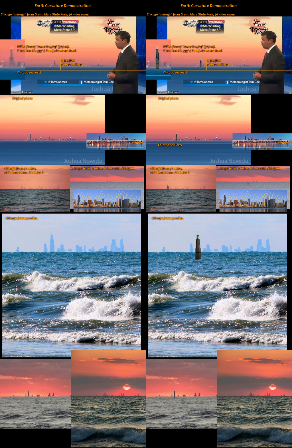
Anyway, the case is similar to point 3, and many of us, myself included, have seen the curvature of the sea hide first the base and then the tops of cliffs as we sailed out  over the curve. And look at this photograph of the world’s largest sailing ship – see how its hull is hidden below the horizon. The sea is curved.
and this one, by an amateur – more photos and an explanation here


For more on this see the reply to point 138 later.


And here’s another video showing a sailing vessel sinking below the horizon.


https://www.youtube.com/watch?v=7nUFLLUahSI


Here's some more water that isn't level: (click for the large version)

[​IMG]


5) “One portion of the Nile River flows for a thousand miles with a fall of only one foot. Parts of the West African Congo, according to the supposed inclination and movement of the ball-Earth, would be sometimes running uphill and sometimes down. This would also be the case for the Parana, Paraguay and other long rivers.”

This looks like Mr Dubay is repeating ‘Proof’ 4 with a different river, and with the same confusion. He often makes the same point again and again, presumably to pad out his number of proofs to “200”.

Anyway his claim is plain false. Pants-on-fire-false actually. Again, there is no long stretch on earth where any river flows upwards under normal conditions. Here's a diagram showing the Nile's elevation:  

The claim of a one-foot drop over 1000 miles is just false. 


Maybe Dubay is confused about what 'up' means? Apparently, he thinks that if you don't glue them down, things in Australia would fall off if they aren't glued down. Because, you know, gravity is a myth or something?


Monday, 1 February 2016

 3) “The natural physics of water is to find and maintain its level. If Earth were a giant sphere tilted, wobbling and hurdling through infinite space then truly flat, consistently level surfaces would not exist here. But since Earth is in fact an extended flat plane, this fundamental physical property of fluids finding and remaining level is consistent with experience and common sense.”

Dubay claims that truly flat surfaces wouldn’t exist on a sphere. Not for the last time, Mr Dubay shows that he doesn’t understand why numbers and quantities matter when seeking the truth.
 Do the mathematics. Work out how large the curvature would be on a sea or large lake , given an Earth with a diameter of 7,900 miles.

Of course, we have been seeing the curvature for as long as we have been going to sea.

In the days of sail, sailors often noticed that they could see other ships further off if they climbed to the tops of their masts. This was an important factor in times of war or piracy.

One thing that Dubay doesn’t understand is that the difference between water being level, and its supposedly being flat. A level ocean, on the Earth’s surface, means that the surface is the same distance from the earth’s centre of gravity. It has run “downwards” (that is, inwards) as far as it can go!

And the Earth is not “wobbling and hurdling” – its slightly elliptical path around the sun is quite steady and not at all ‘wobbly’ – there is nothing to make it wobble, despite Dubay believes. Again, he simply doesn’t understand the ideas that he is criticising.
For those who understand geometry, the surface of the water is perpendicular to the centre of the earth at every point.

·         (Note: Not all water is actually flat. 
  • Very small drops are slightly curved because of surface tension. On a small scale, surface tension is stronger than gravity. So we get this shape 
  • The wind causes waves which roughen the surface very slightly.
  •   Oceans aren’t completely level because of tides.


 2) “The horizon always rises to the eye level of the observer as altitude is gained, so you never have to look down to see it. If Earth were in fact a globe, no matter how large, as you ascended the horizon would stay fixed and the observer / camera would have to tilt looking down further and further to see it.”

This is nonsense. It just isn’t true. 

Do your own research: here is  a simple way to test this for yourself.

Find a view like this of a tall building and take picture like this:


Draw the red lines to extend the horizontal base of any high windows, bricks, slabs etc. towards the horizon.

You will find that the lines converge above the horizon, not on it.
I don't think that anyone would accept this claim if it wasn't hard to see the drop of the horizon with the naked eye. Taking a photo and checking than lines disproves Dubay's claim instantly.

You can see the same thing here:


and in this video


For more discussion on this,claim see here : https://www.metabunk.org/how-to-show-the-horizon-is-below-eye-level-using-actual-eyes.t8845/#post-207592  (thanks to Rory for the links above)

More evidence against this claim:

It depends how high you go. Plenty of people have gone high enough to see it, but flat earthers evade that by claiming that  “they’re all in on the conspiracy, and their photos are fakes”. 

As Daimonie shows:

How to calculate the
distance to the Horizon given
your height.

“The horizon always rises? No, it doesn't. What do you think the horizon is, some mythical creature? Let's show what it is. Suppose for a moment that you're shining a laser while standing on a huge sphere. You start by pointing it upward, then move it downward towards your feet. The Horizon will be that point where the laser first hits the sphere. Yes, again, it is that simple. A slightly more complicated story allows us to calculate. I took it off Wikipedia/Horizon, and it includes the calculation.”

Again, see this video for more details


More on this claim:

https://www.metabunk.org/debunk-the-horizon-never-falling-as-proof-of-flat-earth-theory.t4671/

https://www.metabunk.org/measuring-horizon-drop-and-earths-equatorial-bulge-from-rocket-launches.t9028/#post-210105

Newly added 26th Dec 2018:

Horizon Drop at Varying Altitudes. Flat Earth Debunked.


In his video, flat earther supporter Antonio Subirats explains accurately why the horizon should drop measurably on a globe, but not noticeably on a flat earth. His logic is claer and correct, and he staes clearly that, 
  • If the horizon falls as the viewpoint becomes higher, the earth is curved into a globe;
  • If the horizon does not fall, the earth is flat.

He suggests a test using a tube, and prtedicts that the horizon will not fall, like Dubay and most flat earth beleives. However, using the water level shown here is likely to be more accurate ,  the water level has been recommended by flater earthers and it makes it obvious when the device is really level, and to make the levelling obvious to the eye and indisputable. The two vertical tubes are linked so that the water level is the same in each tube, so when the water surface is aligned in the front and rear tube, the line between them must be level on either flat or globe earth.

Such levels have been used and advocated by flat earth supporters in other cases, so the reliability of the instrument and method should not be in dispute.

I've shown screenshots from the video at each level. The annotations are mine. You can check them against the video at any point where the water level device is held level, with the water in both tubes level.

On the beach just above sea level:


Now at 1200 feet:
and at 5600 feet:

The conclusion is obvious. As we rise higher, the horizon really does fall. Flat earth advocate Antonio Subirat's experiment has be tested and the result (as in the tests above, and many others, was what he stated was  a demonstration of the spherical earth.

To repeat - see how this claim was conclusively refuted by trying a test a globe denier suggested, see these videos. Briefly, Antonio Subairats suggesed taking a tube on a tripod  and lining it up with the horizon.

Then look through the other end of thetubeat the opposite horizon.  Subirats said, rightly, that if the earth was flat, the opposite horizon would be lined up precisely in the tube, too; while on a globe, the opposite end of the tube would be pointing above the horizon. His logic is fine -, that is what we should expect in each case.

So debunker Critical Think did this, carefully, and recorded it. 

Guess what! By this flat-earther's own test, the earth is a globe, and the horizon is not always at eye level. 

Here are all the videos of Critical Think's test;
The Infamous "Red Tube Experiment